Site Search


Course Navigation

Home| Course Catalog| Career Planning

Free Online Course on World Geography, Weather, Climate & Regions

Lesson 6: The Shape of the Land: Where in the world is that?


Atlantic Ocean

Figure 6.2.3, The North Atlantic Ocean Basin.

Figure 6.2.4, Mid-Atlantic Ridge.

The hourglass-shaped Atlantic Ocean covers approximately 20 percent of the earth's surface and is the second largest of the four oceans. It extends from the North Pole southward for 10,000 miles to the Antarctic continent and covers 41 million square miles. Width of the Atlantic Ocean varies from 1,769 miles between Brazil and Liberia and approximately 3,000 miles between Norfolk, Virginia, and Gibraltar.

More is known about the Atlantic Ocean than any other ocean because of heavy commercial and military ship traffic connecting Europe and North America. Average depth is 12,000 feet and the greatest depth is 28,374 feet in the Puerto Rico Trench. If Alaska's Mount McKinley (20,320 feet) was to rise from the floor of the Puerto Rico trench, its peak would still be about 1.5 miles below the surface of the Atlantic.

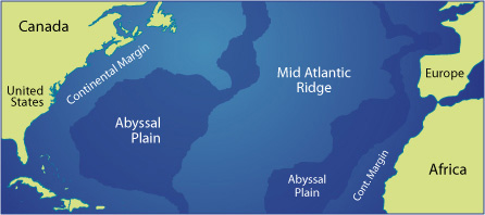
The Mid-Atlantic Ridge divides the seafloor nearly through the center and stretches from the polar regions of the north to Antarctica in the south. The Mid-Atlantic Ridge was created when the super continent of Pangaea split apart 190 million years ago. The ridge lies about 10,000 feet below the water level except in a few areas where it surfaces as islands. This mountain range is as much as 500 miles wide. Rugged valleys extend outward from the ridge line to the abyssal plains.

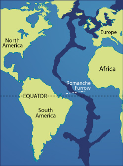
The Mid-Atlantic Ridge is a continuous feature of the basin floor with one exception. There is a significant break in the ridge near the equator at the Romanche furrow where the crest of the ridge dips 15,000 feet below the surface. This break in the mountain chain allows deep water to flow freely between the Atlantic Ocean's east and west sides. This unrestricted movement provides a thorough circulation of the ocean basin that has a pronounced effect on deep water currents, density, and temperature.


  This work is licensed under a Creative Commons Attribution-Noncommercial-Share Alike 3.0 Unported License.
For more information about this and other OCW projects at BYU, visit http://ocw.byu.edu.
Creative Commons License

Our Network Of Sites:
Apply 4 Admissions.com              | A2ZColleges.com  | OpenLearningWorld.com  | Totaram.com
Anatomy Colleges.com                | Anesthesiology Schools.com  | Architecture Colleges.com | Audiology Schools.com
Cardiology Colleges.com            | Computer Science Colleges.com| Computer Science Schools.com| Dermatology Schools.com
Epidemiology Schools.com         | Gastroenterology Schools.com  | Hematology Schools.com     | Immunology Schools.com
IT Colleges.com                | Kinesiology Schools.com  | Language Colleges.com  | Music Colleges.com
Nephrology Schools.com             | Neurology Schools.com  | Neurosurgery Schools.com | Obstetrics Schools.com
Oncology Schools.com    | Ophthalmology Schools.com | Orthopedics Schools.com       | Osteopathy Schools.com
Otolaryngology Schools.com| Pathology Schools.com  | Pediatrics Schools.com  | Physical Therapy Colleges.com
Plastic Surgery Schools.com| Podiatry Schools.com  | Psychiatry Schools.com   | Pulmonary Schools.com 
Radiology Schools.com| Sports Medicine Schools.com| Surgery Schools.com | Toxicology Schools.com
US Law Colleges.com| US Med Schools.com | US Dental Schools.com

About Us Terms of Use | Contact Us | Partner with Us | Press Release | Sitemap | Disclaimer | Privacy Policy


©1999-2011 OpenLearningWorld . com - All Rights Reserved