|

IDENTIFY THE ADVANTAGES AND DISADVANTAGES OF DIFFERENT TYPES OF MAP PROJECTIONS.We have already looked at several different types of maps, or map projections. For this objective you will learn about some of the different projections and how they are used. Maps are made for many reasons, and as a result there are many kinds of maps. Some are made for general purposes, showing roads, towns and cities, rivers and lakes, parks, and state and local boundaries. Other maps are much more specific, conveying information primarily on a single topic. Every map is made for a purpose and serves that purpose best. We will begin with a discussion of maps from the United States Geological Survey.
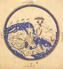
The history of civilization has been illustrated by maps—battle maps by soldiers, exploration maps by empire builders, and thematic maps by scientists. By modern convention, and for no scientific reason, modern maps are usually oriented with north at the top. But a map could have east, west, or south at the top. In 1154 an Arab geographer, Al Idrisi, created Figure 2.1.1. On this world map the Arabian Peninsula is shown at the top center of the map, with south at the top. Different societies in various places have diverse perspectives, which may result from differences in physical geography, language, religion, cultural values and traditions, and history. Even within specific cultures, times, and geographic realms, maps can vary widely. Maps are the result of conscious design decisions. Cartographers (which is just a fancy word for mapmakers) decide how to generalize and symbolize what they are trying to show. They select features or themes to show and others to omit. They often make data general and simplified so that the information on the map is easier to read. When choosing the scale of a map, mapmakers determine how large an area and how much detail they can show. The selection of symbols (which can include lines, patterns, and colors) also affects the legibility, beauty, and utility of the map. Cartography blends science and art. A beautiful map may become popular, even though it may be less accurate than a plainer version. Details of cartographic style affect how a map is perceived, and perception varies with perspective. In short, people understand the world differently, and these differences are apparent in the various ways people create and understand maps. Geographic information included on a map varies. Maps might include such features as coastlines, boundaries, roads, rivers, lakes, cities, towns, mountains, place names, latitude, and longitude. As you learned earlier, it is difficult to create a flat map of a spherical surface, doing so causes some distortion. The choice of map projection determines how and where a map is distorted. A map's purpose is usually clear from its title and explanation, but other information such as the author, date, publisher, source of funding, etc. may also hint at why and for whom the map was made. A knowledgeable map reader, recognizing that a map is both a simplification and a distortion of reality, will look for clues to the cartographer's purposes and biases.1 Footnotes 
|


About Us | Terms of Use | Contact Us | Partner with Us | Press Release | Sitemap | Disclaimer | Privacy Policy
©1999-2011 OpenLearningWorld . com - All Rights Reserved